News
Johns Hopkins APL Is Setting the Path to Prevent Traffic Jams in Space
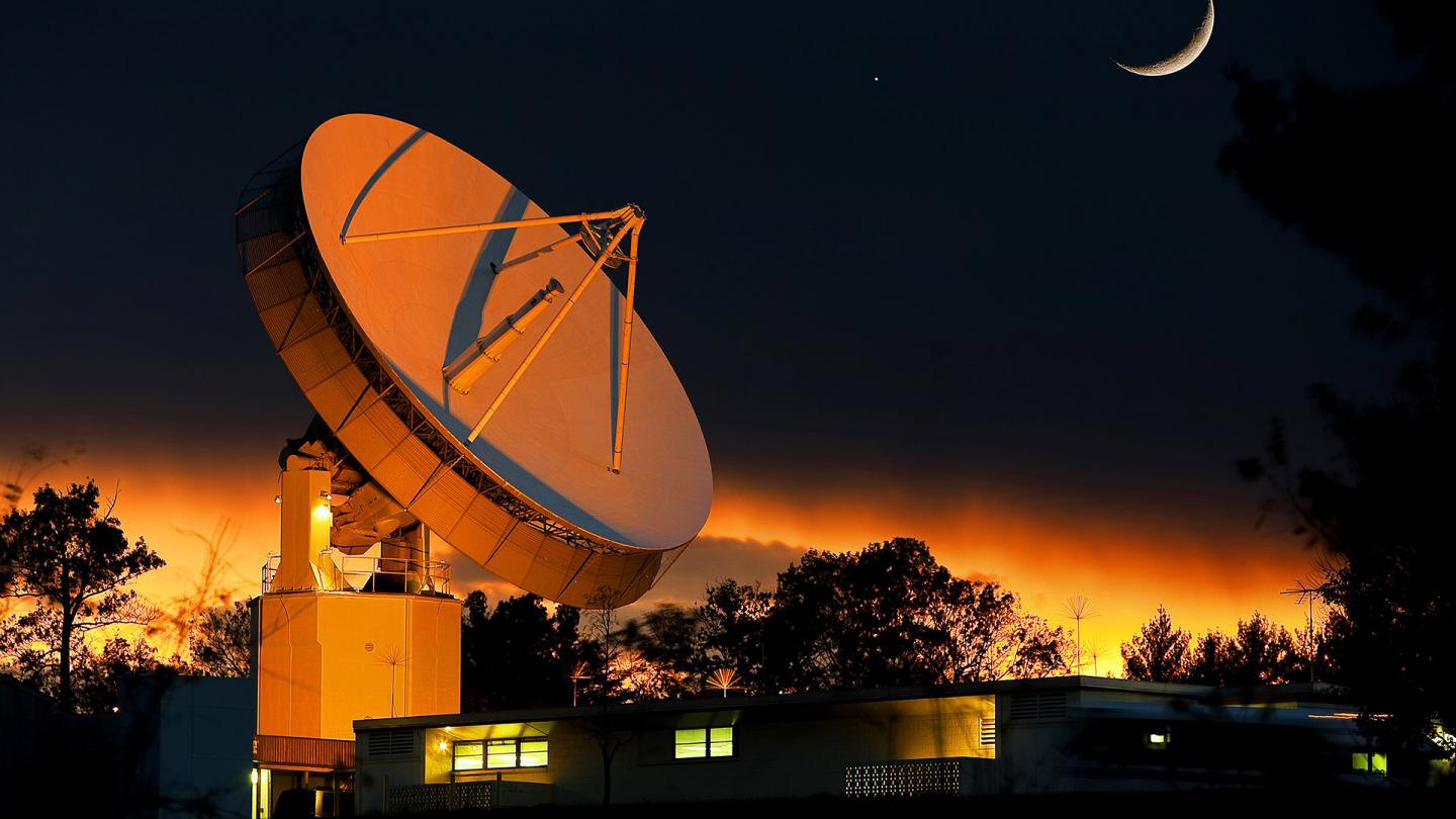
The Very Long Baseline Interferometry team used APL’s 60-foot antenna to demonstrate a technique for tracking spacecraft in cislunar space.
Credit: Johns Hopkins APL
Today, traffic in cislunar space might look like a quiet country road. It may never grow to resemble rush hour in Times Square, but experts believe the region will get much busier, prompting a need for additional situational awareness capabilities to prevent space traffic jams.
Cislunar is the space below the Moon and above geosynchronous Earth orbit — about 22,000 miles (or 35,000 kilometers) from Earth’s surface — and the Moon’s orbit at 236,000 miles (380,000 kilometers) away from Earth’s surface. Easier access to space, enabled by the increase in commercial launch capabilities, has opened new possibilities for both countries and companies to use this region and the lunar surface for a variety of purposes, ranging from placing military assets and conducting science to mining resources and manufacturing in space.
Space industry consultants Quilty Analytics expect more than 100 missions to launch to the Moon over the next decade, more than were launched even in the first decade of the Space Race, and each will contribute to the proliferation of artificial objects in the region.
“If you just think about NASA’s Artemis missions, Artemis I will release seven CubeSats,” said Wayne Schlei, a mission design engineer and co-lead of cislunar projects at the Johns Hopkins Applied Physics Laboratory (APL) in Laurel, Maryland. “That’s in addition to the vehicle service module and the upper stage it is using to get to cislunar space. That’s only one mission, and suddenly you have 10 new pieces of hardware in that region.”
Teams from APL’s Space Exploration Sector have been exploring technical concepts to provide greater situational awareness to enhance safety and security for those who plan to operate in cislunar space and on the Moon.
Sensing and Tracking Spacecraft
This summer, Erin Fowler, an APL aerospace engineer, led a project to evaluate the use of very long baseline interferometry (VLBI) to track spacecraft in cislunar space.
Often used in radio astronomy, VLBI is a technique to observe phenomena in greater resolution than would be possible with even the largest single telescope. In VLBI, multiple telescopes collect a radio signal. The time difference between the arrival of the signal at the telescopes is then used to calculate their distance from one another. This allows the observations of the same signal made by many telescopes to be combined. The resulting observation mimics that of a telescope with a size equal to the maximum separation between telescopes. The farther the telescopes are from each other, the higher the resolution of the observation.
The technique is typically used to observe distant phenomena, like quasars — extremely luminous objects found at the center of some galaxies, powered by supermassive black holes. It has been demonstrated for spacecraft tracking but is not commonly used to track spacecraft in the cislunar region.
Fowler’s team conducted a simulation study to determine whether it would be valuable to use VLBI to enhance spacecraft tracking capabilities in cislunar space. Using a simulation of entirely ground-based telescopes, the team found that it would be a helpful solution for space domain awareness. But when a space-based telescope was added to the simulated ground-based assets, the team noticed an exciting improvement in tracking ability.
Because it would be stationed off the surface of the Earth and move in its orbit, such a satellite would greatly increase the distance between telescopes, in turn improving the resolution of the observation. Adding a second satellite to the system would help even more.
“We didn’t look at having the entire system on orbit due to the expense of creating a system like that, but scheduling the use of really capable ground-based assets, like the ones needed for VLBI, can be tough,” Fowler said. “There may come a point when it would be worth looking at other, more dedicated options, like an entirely space-based system.”
VLBI comes with limitations, however. Primary among them is that the spacecraft must be actively emitting a radio signal for the method to work. The VLBI system would view the spacecraft while it is emitting the signal, then propagate the spacecraft’s track forward, predicting where it will be the next time it emits a signal.
In general, it is safe to assume a spacecraft will emit a radio signal fairly regularly to communicate data to Earth or to receive commands from mission control. But a new communications method using optical signals is becoming more and more popular due to the faster rate of data throughput. VLBI would not be relevant in the case of optical signals because of their much narrower beamwidth.
“By itself, VLBI is not a full solution for cislunar space domain awareness,” Fowler said, “but it could be a helpful piece of the puzzle when used in concert with other sensors and methods.”
As a passive radio frequency (RF) sensing method, VLBI can collect observations even when other sensor types experience outages. For instance, an optical telescope cannot make observations when its target object is not lit or is too close to the Sun or Moon from the perspective of the observer.
In a hybrid cislunar space domain awareness strategy, optical sensing methods might be used when a target object is not emitting an RF signal, and passive RF techniques like VLBI might be used when optical sensing is impossible because of Sun and Moon geometry. A hybrid system provides more consistent coverage through the various outages and constraints that afflict individual sensing techniques.
Using Data to Enhance Operational Planning
While sensing and tracking spacecraft in cislunar space is one piece of the challenge of space domain awareness in the region, another piece is creating a database of that information and visualizing it so that experts and mission operators can easily plan future operations.
Schlei is working with colleagues at APL on a project called the Deep Space Catalog, an evolution of an existing database of near-Earth spacecraft and artificial objects.
“The current catalog is used to ensure missions under development will not have a chance greater than a certain threshold of a close approach or even a potential collision with another spacecraft,” Schlei said. “There is a need to enhance the catalog for greater situational awareness in the cislunar and lunar region to mimic what we see in Earth orbit.”
As part of the Deep Space Catalog project, Schlei and his team are gathering data from many sources to form a database of artificial objects in the cislunar region and deep space. The catalog will contain information about these spacecraft and objects, helping mission managers to prevent accidental interference, like collisions, and to operate more safely in the cislunar regime and on the lunar surface.
The team is working on a front-end data visualization of the objects in the database, which would allow officials and mission operators to see object locations, mission details and spacecraft capabilities at a glance.
This could be used to prevent accidental interference with others’ operations in cislunar space. It could also be used to enable leaders to see spacecraft and other objects in an operational context and respond to simulated scenarios.
In the long term, the team hopes to leverage APL’s expertise in big data, as well as artificial intelligence and machine learning, to continue to improve the catalog.
“As an organization, we have world-renowned expertise in space systems, lunar science and machine learning, and we can pull from that to help inform the development of these solutions,” Schlei said.
Home to the world’s largest community of lunar experts in a single location, APL is a leader in cislunar security. From Nov. 15 to 17, the Laboratory hosted the third annual Cislunar Security Conference, a forum on the technology, policy, doctrine and strategy implications of ensuring free access to transit and use of the Earth‑Moon system beyond geosynchronous Earth orbit. The gathering encourages national‑level technical discourse related to domain awareness, policy and strategy, communications and infrastructure, trajectory design, threats, position, navigation and timing for cislunar security.