Press Release
Global Map Reveals Mineral Distribution on Mars
After a year in Mars orbit, CRISM has taken enough images to allow the team to release the first parts of a global spectral map of Mars to the Planetary Data System (PDS), NASA's digital library of planetary data.
CRISM's global mapping is called the "multispectral survey." The team uses the word "survey" because a reason for gathering this data set is to search for new sites for targeted observations, high-resolution views of the surface at 18 meters per pixel in 544 colors. Another reason for the multispectral survey is to provide contextual information. Targeted observations have such a large data volume (about 200 megabytes apiece) that only about 1% of Mars can be imaged at CRISM's highest resolution. The multispectral survey is a lower data volume type of observation that fills in the gaps between targeted observations, allowing scientists to better understand their geologic context.
The global map is built from tens of thousands of image strips each about 10 kilometers (6.2 miles) wide and thousands of kilometers long. During the multispectral survey, CRISM returns data from only 72 carefully selected wavelengths that cover absorptions indicative of the mineral groups that CRISM is looking for on Mars. Data volume is further decreased by binning image pixels inside the instrument to a scale of about 200 meters (660 feet) per pixel. The total reduction in data volume per square kilometer is a factor of 700, making the multispectral survey manageable to acquire and transmit to Earth. Once on the ground, the strips of data are mosaicked into maps. The multispectral survey is too large to show the whole planet in a single map, so the map is divided into 1,964 "tiles," each about 300 kilometers (186 miles) across. There are three versions of each tile, processed to progressively greater levels to strip away the obscuring effects of the dusty atmosphere and to highlight mineral variations in surface materials.
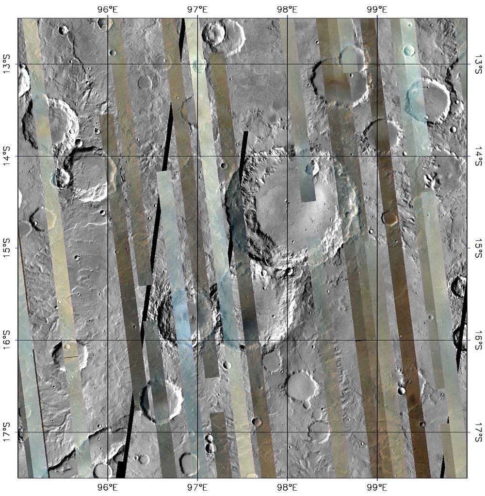
This is the first version of tile 750, one of 209 tiles just delivered to the PDS. It shows a part of the planet called Tyrrhena Terra in the ancient, heavily cratered highlands. The colored strips are CRISM multispectral survey data acquired over several months, in which each pixel has a calibrated 72-color spectrum of Mars. The three wavelengths shown are 2.53, 1.50, and 1.08 micrometers in the red, green, and blue image planes respectively. At these wavelengths, rocky areas appear brown, dusty areas appear tan, and regions with hazy atmosphere appear bluish. Note that there is a large difference in brightness between strips, because there is no correction for the lighting conditions at the time of each observation. The gray areas between the strips are from an earlier mosaic of the planet taken by the Thermal Emission Imaging System (THEMIS) instrument on Mars Odyssey, and are included only for context. Ultimately the multispectral survey will cover nearly all of this area.
Credit: NASA/JPL/JHUAPL/Applied Coherent Technology
Scientists are getting a clearer image of mineral distribution on the surface of Mars, thanks to the Compact Reconnaissance Imaging Spectrometer for Mars (CRISM), one of six science instruments on NASA's Mars Reconnaissance Orbiter, currently circling the planet. More than 200 just-released "spectral maps" reveal the distribution of various minerals on the surface of Mars—the first installment of the Global Mars Map, which will eventually cover the entire planet.
The locations and amounts of these minerals provide clues about the geological processes that created different rock formations, and will provide invaluable pointers to when and where liquid water once existed on Mars. These first maps were selected to cover many of the geologically most interesting parts of the planet and represent about 11 percent of Mars' surface.
Built and operated by The Johns Hopkins University Applied Physics Laboratory (APL), CRISM detects 544 wavelengths of visible and infrared sunlight reflecting off of the planet's surface. Minerals on the planet absorb some of this sunlight, leaving telltale gaps or absorptions in the spectra of the reflected light.
To create the maps, CRISM uses a multispectral survey mode of operation, collecting data from just 13 percent of the available wavelengths to highlight key mineral groups. This lower data-rate mode, coupled with other onboard data compression, decreases the data volume significantly and makes it possible for CRISM to extend its measurements beyond a few thousand targets to cover the entire planet.
Each section, or tile, of the Global Mars Map shows a visible-infrared image of a swatch of the planet's surface about 300 kilometers (186 miles) wide, overlaid with 10 kilometer-
(6.2 mile-) wide strips of the CRISM spectral data. By creating the map tiles, the CRISM team is providing scientists with a unique tool in the form of uniformly processed data, saving them from the lengthy task of processing the image strips themselves.
This initial release of map tiles includes fully calibrated measurements, but without any correction for the obscuring effects of Mars' atmosphere. For the future, we're working on an experimental correction for the atmospheric effects and a series of ‘summary' tiles that will capture key information about surface composition," says APL's Scott Murchie, CRISM principal investigator.
"We'll continue to add to the Global Mars Map until we've mapped the entire planet, in 1,964 tiles," says Christopher Hash of Applied Coherent Technology, Inc., in Herndon, VA, which is responsible for the specialized software to produce the tiles.
Researchers can access the Global Mars Map through NASA's Planetary Data System Geosciences Node. Samples of the tiles can be found under "Featured Images" on the CRISM home page.
APL, which has built more than 150 spacecraft instruments over the past four decades, led the effort to develop, integrate and test CRISM. The CRISM team includes experts from universities, government agencies and small businesses in the United States and abroad; visit http://crism.jhuapl.edu for more information. Information about the Mars Reconnaissance Orbiter and Mars Science Laboratory missions is available online at http://mars.jpl.nasa.gov/. The Jet Propulsion Laboratory, a division of the California Institute of Technology, manages the MRO mission for the NASA Science Mission Directorate, Washington. Lockheed Martin Space Systems, Denver, is the prime contractor and built the MRO spacecraft.
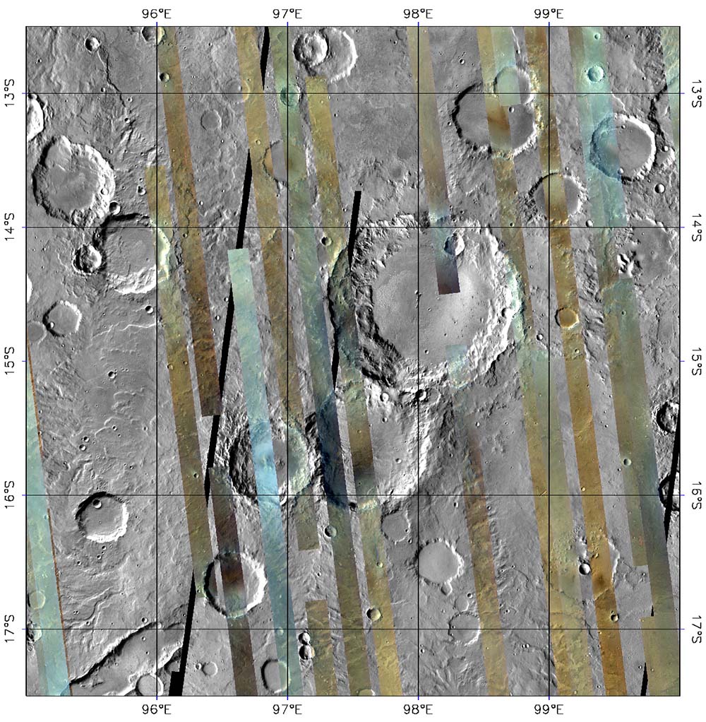
This is the second version of tile 750, in which a still-experimental correction for illumination and atmospheric effects has been applied. It shows a part of Mars called Tyrrhena Terra in the ancient, heavily cratered highlands. The colored strips are CRISM multispectral survey data acquired over several months, in which each pixel has a calibrated 72-color spectrum of Mars. A mathematical model of the effects of seasonal variations Mars' atmosphere has been used to correct brightness to how it would appear if each strip was imaged with the same illumination and without an atmosphere. The three wavelengths shown are 2.53, 1.50, and 1.08 micrometers in the red, green, and blue image planes respectively. Compared to data without corrections, strip-to-strip brightness differences have largely been eliminated. The residual bluish color of some areas is due to clouds that were not included in the mathematical model. The gray areas between the strips are from an earlier mosaic of the planet taken by the Thermal Emission Imaging System (THEMIS) instrument on Mars Odyssey, and are included only for context. Ultimately the multispectral survey will cover nearly all of this area.
Credit: NASA/JPL/JHUAPL/Applied Coherent Technology

This is the third and most processed version of tile 750, showing a part of Mars called Tyrrhena Terra in the ancient, heavily cratered highlands. The colored strips are CRISM multispectral survey data acquired over several months, in which each pixel began as calibrated 72-color spectrum of Mars. An experimental correction for illumination and atmospheric effects was applied to the data, to show how Mars' surface would appear if each strip was imaged with the same illumination and without an atmosphere. Then, the spectrum for each pixel was transformed into a set of "summary parameters," which indicate absorptions showing the presence of different minerals. Detections of the igneous, iron-bearing minerals olivine and pyroxene are shown in the red and blue image planes, respectively. Clay-like minerals called phyllosilicates, which formed when liquid water altered the igneous rocks, are shown in the green image plane. The gray areas between the strips are from an earlier mosaic of the planet taken by the Thermal Emission Imaging System (THEMIS) instrument on Mars Odyssey, and are included for context. Note that most areas imaged by CRISM contain pyroxene, and that olivine-containing rocks are concentrated on smooth deposits that fill some crater floors and the low areas between craters. Phyllosilicate-containing rocks are concentrated in and around small craters, such as the one at 13 degrees south latitude, 97 degrees east longitude. Their concentration in crater materials suggests that they were excavated when the craters formed, from a layer that was buried by the younger, less altered, olivine- and pyroxene-containing rocks.
Credit: NASA/JPL/JHUAPL/Applied Coherent Technology